
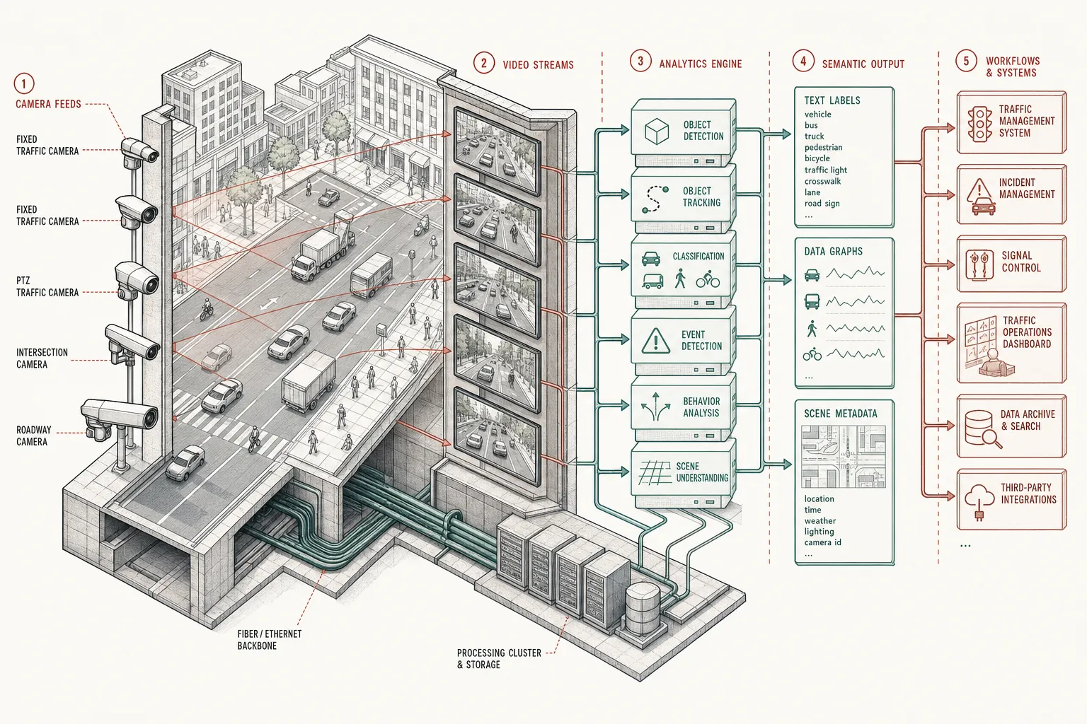
Reality capture is ceasing to be the fundamental bottleneck. The constraint on spatial intelligence has shifted from seeing reality to understanding it, and ultimately to deciding what to do about it.
CCTV solved the first iteration of persistent reality capture: place enough sensors in physical space and continuous observation becomes possible. Drones extended that field of view into places where fixed optics could not reach—construction sites, linear corridors, river basins, and agricultural grids. Traditional computer vision then made the resulting pixel streams machine-readable: once a model saw enough potholes, vehicles, cracks, or encroachments, it could find more of them.
What is changing now is the fidelity and economics of representation itself. Infrastructure management is moving away from periodic orthomosaics and batch photogrammetry toward systems capable of synthesizing continuous 3D representations from video, phone clips, drone passes, and fixed CCTV feeds. The remaining bottlenecks are operational—compute cost, storage, coverage, latency—rather than questions of technical feasibility.
From Bounding Boxes to Linguistic Representation
The more consequential shift is not 3D reconstruction, but vision-language models. Traditional computer vision asks a predetermined, closed-taxonomy question of an image: Is there a pothole at these coordinates? Is there a vehicle in this lane?
A vision-language model (VLM) describes the scene before every question has been decided. It converts raw pixels into an open-ended linguistic representation of physical space. Once the physical world becomes describable in language, it becomes queryable by the exact same infrastructure used to reason over documents, databases, contracts, and municipal regulations.
"The limits of my language mean the limits of my world."1 — Ludwig Wittgenstein, Tractatus Logico-Philosophicus, 5.6
There is an interesting technological inversion of Wittgenstein's thesis. VLMs are rapidly expanding the vocabulary machines possess for the physical world. A road segment is no longer merely a sequence of RGB pixels or a static GIS polyline. In a linguistic representation, it becomes:
- Waterlogging beginning adjacent to a blocked stormwater drain
- Three pavement defects increasing in surface area over 30 days
- Construction debris narrowing an active carriageway
- A street light obscured by unpruned vegetation
Suddenly, physical observations can directly interact with software systems that speak language: municipal budgets, automated work orders, defect-liability clauses, citizen complaints, and historical maintenance logs.
The Selective Compute Funnel
India does not need another generation of administrative dashboards. Public agencies already generate extraordinary volumes of imagery and digital exhaust. The opportunity lies in building a software layer capable of executing a continuous loop:
Observe → Describe → Compare → Prioritise → Recommend Action
Executing continuous 3D reconstruction across an entire city alongside real-time VLM inference over thousands of high-bitrate video streams remains computationally extravagant. Universal multi-modal inference at the edge is financially impossible for municipal budgets today.
The viable spatial architecture for developing nations is therefore selective rather than universal.
Instead of running continuous heavy AI across all inputs, a practical spatial computing system operates as a gated compute funnel:
- Continuous Low-Cost Coverage: Ubiquitous cheap sensors, existing CCTV feeds, and mobile video provide broad baseline coverage.
- Lightweight Anomaly Detection: Small, specialized edge models flag surface changes, motion anomalies, or geometric shifts at near-zero compute cost.
- Triggered Reconstruction & VLM Translation: High-parameter VLMs and dense 3D reconstruction engines are invoked only where an anomaly is flagged.
- Agentic Reasoning & Action: An agentic software layer links the linguistic description to the corresponding physical asset, defect liability period, municipal budget, and decision-maker.
| Stage | Infrastructure Layer | Compute Cost Profile | Primary Function |
|---|---|---|---|
| 1. Capture | CCTV, Phones, Drones, IoT | Low (Commodity hardware) | Continuous physical observation |
| 2. Reconstruct | NeRFs, Gaussian Splatting | Medium-High (Batch / On-demand) | Continuous 3D representation |
| 3. Describe | Vision-Language Models (VLMs) | Medium (Triggered per event) | Converting pixels into natural language |
| 4. Reason | LLMs, Graph DBs, Policy Engines | Low-Medium (Logic synthesis) | Cross-referencing budgets & rules |
| 5. Act | Agentic Workflows & E-Governance | Low (Transactional execution) | Issuing work orders & routing decisions |
The Five-Stage Evolution of Spatial Intelligence
The arc of spatial computing moves across five distinct technical milestones:
Capture Reality → Reconstruct Reality → Give Reality Language → Reason Over Reality → Act On Reality
The first three stages—capturing pixels, reconstructing geometry, and giving physical space a linguistic description—are rapidly becoming technically tractable commodity capabilities.
The unsolved problem—and the true value capture in civic infrastructure—lies in the final two: taking those linguistic descriptions of physical space, reasoning over them against complex institutional constraints, and executing defensible action.
Footnotes
-
"5.6 The limits of my language mean the limits of my world." — The Ludwig Wittgenstein Project, Tractatus Logico-Philosophicus (English) (1922). ↩