
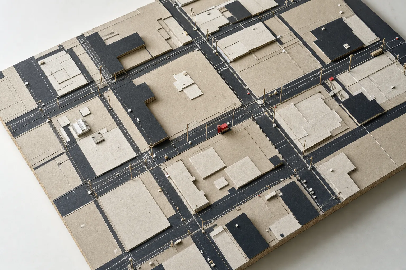
In the early days of the "smart city" movement, the primary challenge was not a shortage of intelligence. It was a shortage of legible reality.
Early municipal drone mapping initiatives began with a deceptively simple premise: if cities were going to become computational systems, they first needed an accurate digital representation of themselves. The physical city had to be made machine-readable before software could meaningfully help govern it.
At the time, this was not a trivial assumption.
Government information systems were fragmented across departments. Planning drawings often represented different moments in time. Utility information sat in separate databases or, sometimes, physical files. Satellite imagery could provide broad spatial context, but not always the resolution, frequency or local accuracy required to distinguish the individual objects through which cities actually functioned: roads, footpaths, buildings, trees, poles, wells, drains and manholes.
The article described this as a foundational problem. The precision of the map mattered because every application built on top of it inherited the quality of that representation. A smart city could have sophisticated dashboards, sensors and management information systems, but if its underlying understanding of what physically existed was wrong, the sophistication merely sat on top of bad ground truth.
Early drone surveying pilots were an attempt to solve that problem.
Drones as an information infrastructure
The argument was not that drones should replace every other surveying technology. Satellites, total stations and conventional surveys would continue to have roles. Drones provided another layer: dense, inexpensive and repeatable local observation.
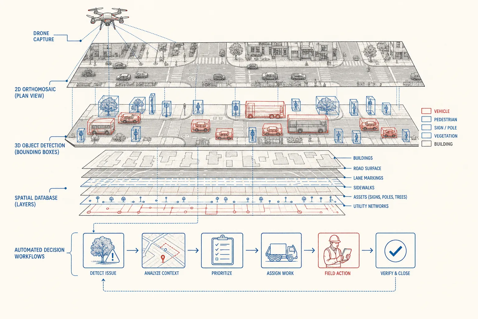
Using photogrammetry, image processing and ground-control points, imagery could be converted into high-resolution orthomosaics, elevation models, point clouds and 3D reconstructions.
The significance wasn't the drone itself. It was the ability to dramatically lower the cost and time required to create an authoritative spatial representation of an urban area.
For typical 1,000-acre urban survey projects, work that previously required nine or ten months through conventional surveying could be completed in under a month, including web delivery. The resulting imagery reached approximately 2.26 centimetres per pixel with stated positional accuracy of roughly 5–7 centimetres.
That resolution changed what counted as data.
It was no longer enough to say that there was a road in a particular area. The system could distinguish the road from the adjoining footpath. Individual electric poles, wells, empty plots, building footprints, trees, manholes and water bodies could become identifiable objects with geographic coordinates.
In early field implementations, small four-person surveying teams mapped hundreds of kilometres of road networks and footpaths, identifying thousands of electric poles, wells, empty plots, trees, and manholes alongside building footprints and water bodies.
That is an important conceptual shift.
Aerial imagery stopped being merely a picture of the city. It became a database of the city.
The real problem was interoperability
The article then moved beyond surveying.
Creating beautiful 3D models was not enough. Urban planning continued to happen through AutoCAD, GIS software, departmental MIS systems and other existing tools. New geospatial information therefore had to be interoperable with the systems through which government actually worked.
The article identified interoperability as one of the major bottlenecks to smart cities. Its proposed architecture was essentially to create a common spatial layer into which otherwise disconnected information could be attached.
Property information could occupy one layer.
Road infrastructure another.
Utilities another.
IoT sensors another.
Administrative information another.
Instead of each department maintaining an independent picture of reality, location could provide a common reference system.
The article called this a “geospatial anchor” for other insights.
This mattered because the real promise of mapping was not visualization. It was integration.
A sensor reading becomes more useful when you know precisely where the sensor is.
A complaint becomes more useful when you can associate it with a road, parcel, ward and responsible authority.
A property record becomes more useful when it can be reconciled with the physical building that actually exists.
The map becomes the join key through which disparate government information begins to describe the same world.
And then came the computational problem
Toward the end of the article, the argument moves one step further.
Once a city can be captured at centimetre-level detail, manually interpreting everything becomes its own bottleneck. Producing enormous point clouds or imagery simply creates another labour problem if hundreds of people must inspect and digitise them.
Hence the line:
Maps are raw materials.
The ambition was to use computation to extract structured geospatial features automatically from imagery and point clouds. Instead of teams manually tracing every road, building, tree or pole, machine-learning systems could increasingly recognise those objects themselves.
Read in 2026, this is perhaps the most interesting part of the article.
Because it reveals the technological assumption of that period remarkably clearly.
The pipeline was moving toward:
physical world → imagery → map → objects → information → human decision
The computer's job was increasingly to understand the first half of that chain.
The human still occupied the second.
Decades later, the interesting question has moved
Much of what appeared computationally difficult in early smart-city initiatives has become substantially easier.
Modern geospatial systems can perform automated segmentation, classification, object detection, change detection and predictive analysis at scales that were much harder to achieve then. More recently, geospatial foundation models have begun learning reusable representations from maps, satellite imagery and other geographic information rather than requiring a separate bespoke model for every narrow task. Esri now describes more than 100 pretrained AI models in ArcGIS and is introducing foundation models designed for feature extraction, similarity search, predictive modelling and natural-language interaction with geographic information.1
But something more consequential has happened outside GIS.
Foundation models learned to reason across different kinds of information.
Then they acquired tools.
And now they are acquiring agency.
Which changes the smart-city question fundamentally.
In the first era of smart cities, the question was:
Can the machine understand what exists?
Increasingly, the question is:
Can the machine determine what should happen next?
And after that:
Can we allow it to make it happen?
From perception to agency
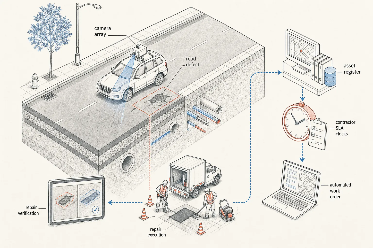
Consider something as mundane as a pothole.
The early technological achievement was being able to map the road accurately enough that its geometry and condition could become digital information.
Computer vision subsequently made it possible to identify the pothole automatically.
That gives us:
Road → image → defect detection
Useful, but still fundamentally an analytics workflow.
Someone still has to see the detection, understand its importance, determine who owns the road, establish whether a contractor is responsible for it, assign the repair, monitor progress and verify completion.
Agentic AI changes the boundary of what the machine can plausibly do.
A future system might:
- detect the defect from a vehicle-mounted camera;
- compare it with previous observations and establish that it is new;
- estimate its severity and safety implications;
- associate its coordinates with the correct road segment;
- query the asset register to determine ownership;
- inspect the maintenance contract to determine whether the road remains under defect liability;
- check whether another complaint or work order already exists;
- combine the defect with traffic and risk information to assign priority;
- generate the appropriate work order;
- route it to the responsible contractor or engineer;
- track whether the SLA is being breached;
- analyse subsequent imagery to determine whether the repair occurred;
- and escalate discrepancies to the appropriate authority.
The underlying geospatial technology remains essential.
But the value of the system has moved.
The product is no longer merely a map of the pothole.
It isn't even an AI model that detects the pothole.
The useful unit is increasingly:
the pothole resolved.That distinction has enormous consequences.
The digital twin becomes a world model
This also changes the meaning of the much-abused phrase digital twin.
For years, digital twins were frequently presented as sophisticated representations of physical assets: 3D models, sensor overlays, simulations and dashboards.
They allowed a person sitting in a control room to inspect another representation of reality.
Agentic systems give the twin a much deeper role.
The twin can become the world model against which an agent reasons.
The agent needs to understand:
- what exists;
- where it exists;
- what state it is currently in;
- what changed;
- what is related to what;
- who owns what;
- what rules govern each entity;
- which actions are possible;
- and what happened the last time an action was taken.
Spatial information provides one of the organising structures through which all of this can be reconciled.
So the evolution is roughly:
Map → GIS → spatial database → digital twin → world model
The first describes the world. The second structures it. The third connects information to it. The fourth maintains state. The fifth allows an intelligent system to reason about that state and choose actions within it.
This is why the early smart-city goal of establishing a “geospatial anchor to all your insights” remains relevant but now feels incomplete.
The geospatial layer may increasingly become:
the anchor for insights, decisions and actions.
From an observatory to a control system
This produces another architectural shift.
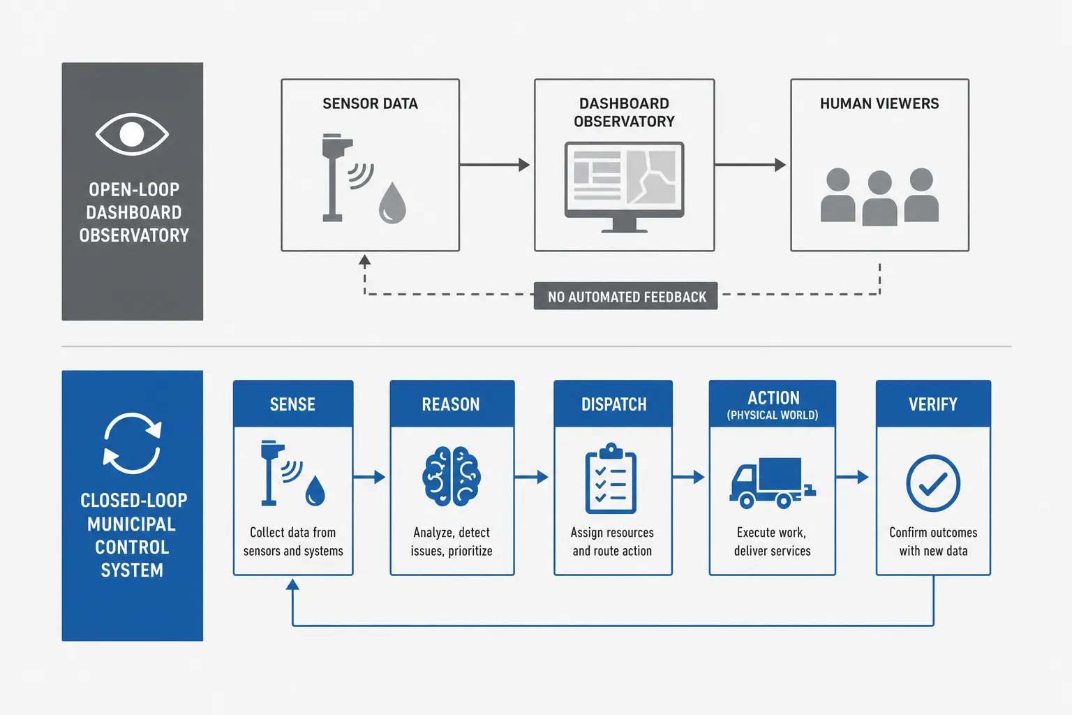
Most first-generation smart-city platforms were fundamentally observatories.
They collected information. They displayed information. They raised alerts. They allowed humans to investigate information.
Their conceptual loop ended at the dashboard:
Reality → Data → Dashboard → Human
Agentic infrastructure potentially creates a closed loop:
Reality → Observation → Representation → Understanding → Reasoning → Decision → Action → Verification → Updated reality
At that point the city platform begins looking less like a dashboard and more like a control system.
This is an important distinction because control systems do not merely know things. They attempt to move the state of a system from one condition to another:
- Flooding detected becomes flooding mitigated.
- Encroachment detected becomes inspection initiated.
- Property discrepancy detected becomes verification requested.
- Water leakage detected becomes repair dispatched.
- Waste accumulation detected becomes pickup scheduled.
- Air-quality deterioration detected becomes an intervention evaluated and initiated.
- Road degradation detected becomes maintenance completed.
The difference between those pairs is precisely the territory that agents are beginning to occupy.
The scarce unit moves again
There is also an economic story hiding inside this technological progression.
Every technological era tends to monetise around something that is scarce.
When surveying was expensive, acres surveyed were valuable.
When computing became software, licences became valuable.
SaaS monetised seats because access to specialised software capability was scarce.
Cloud computing monetised compute.
Generative AI initially monetised tokens because intelligence itself required expensive inference.
But as intelligence becomes cheaper and increasingly interchangeable, the valuable unit moves farther along the chain.
Consider the progression in geospatial technology:
Acres captured → maps generated → objects extracted → changes detected → insights generated → decisions made → actions executed → outcomes achieved
Each transition moves the meter closer to the actual reason the technology was purchased.
No municipality ultimately wants pothole detections. It wants roads without potholes.
No water utility wants leakage alerts. It wants lower non-revenue water.
No city wants property-building reconciliation as an intellectual exercise. It wants an accurate tax base.
The technological possibility of agency therefore starts pulling business models toward the right-hand side of this chain.
Because acting is different from recommending
There is an enormous difference between software telling an administrator:
This property may be incorrectly assessed.
and software issuing a tax reassessment.
Between saying:
This contractor appears to be violating an SLA.
and withholding a payment.
Between detecting illegal construction and issuing a notice.
Between recommending that pumps be activated and actually activating them.
The moment AI crosses from intelligence into execution, a completely different layer of infrastructure becomes important: permissions, authority, identity, policy, auditability, provenance, approval, liability, and reversibility.
OpenAI's current enterprise agent architecture reflects exactly this problem. Workspace agents can operate across tools and workflows, but organisations can specify which tools and actions agents may access, apply role-based controls, require approval for sensitive actions, and maintain audit logs of what an agent did.
Similarly, OpenAI's description of deploying coding agents emphasises not merely model capability but boundaries: what an agent can access, what requires human approval and what telemetry allows its behaviour to be understood afterwards.
This is not incidental governance wrapped around AI. It is part of the product.
Because the scarce capability is no longer merely intelligence. It is trusted delegation.
Which makes the old data problem more important, not less
There is a tempting version of the agentic-AI story in which better models somehow make the messy data infrastructure of governments irrelevant.
The opposite is likely to be true.
Agents increase the cost of bad information. A bad dashboard may mislead someone. An autonomous system acting on bad information can create a bad reality.
Suppose an old municipal database incorrectly identifies which department owns a road. An analytics system displays the wrong department. A human might recognise the error. An agent might automatically generate a work order, send it, start an SLA clock, escalate non-performance and eventually trigger contractual consequences—all from the same incorrect record.
Or consider property information. A model might correctly detect that a building physically exists where the tax system records an empty plot.
But several questions still remain:
- Is the imagery current?
- What is the parcel boundary?
- Is the building legally exempt?
- Is an appeal pending?
- Which record is authoritative?
- What degree of confidence is required before action?
- Who is legally empowered to alter the assessment?
The intelligence problem and the authority problem are different problems. And the second becomes more important as the first gets solved.
So the foundational obsession with accuracy, granularity, interoperability and ground truth was not made obsolete by AI. It became a prerequisite for AI that can act.
The map itself must now change
There is one respect, however, in which the early digital twin architecture is no longer sufficient.
A digital replica was once treated largely as a sufficiently accurate snapshot.
Agents require something closer to a temporal state machine.
They need not only “What is here?” but:
- What was here before?
- What changed?
- When did it change?
- Who changed the official record?
- How certain are we that the physical change is real?
- Which source should be trusted?
- What action was taken previously?
- Did it work?
The database therefore needs history, provenance and uncertainty as first-class properties.
A road cannot merely have a geometry. It has a condition history, a contractor, a warranty period, a maintenance history, complaints, inspections, payments, SLA obligations, detected changes, and pending actions.
The geospatial object becomes the persistent entity around which institutional memory accumulates. That may be one of the most important evolutions from digital map to digital twin.
Agents make interoperability much more consequential
The same is true of the interoperability problem identified in early smart-city deployments.
At the time, compatibility meant that drone-derived information should work inside CAD, GIS and other government systems rather than becoming another silo.
Agentic architectures push the idea much further.
An agent cannot complete the pothole workflow if it can see the GIS but cannot access the contract. It cannot resolve the property discrepancy if it cannot query the tax database. It cannot investigate a grievance without access to the complaint system. It cannot initiate action if the workflow engine exposes no controllable interface.
The interesting integration problem therefore changes from “Can these systems exchange data?” to “Can intelligence safely operate across these systems?”
APIs, schemas and interoperability once existed mainly to move information between applications. Increasingly, they define the action space available to an agent.
Which may finally realise the original promise of smart cities
The phrase “smart city” suffered because the technology often stopped one layer too early.
Cities accumulated cameras, sensors, command-and-control centres, digital maps, dashboards, MIS systems, and analytics. Each generated another representation of what was happening.
But governments were rarely short of things to look at. They were short of institutional capacity to continuously convert what they knew into coordinated action.
Agentic AI is interesting not because cities need another interface containing AI. It is interesting because, for the first time, software may begin absorbing part of the coordination cost between knowing something and doing something.
The limiting factor becomes less “Can we detect the problem?” and increasingly “Can the institution safely delegate the response?”
A useful way to see the entire technological arc
The progression from early drone mapping projects to agentic urban systems can be understood as a series of disappearing bottlenecks:
- Digitisation: Can we create an accurate digital representation of the physical city? (Drones, photogrammetry, LiDAR, satellite imagery)
- Extraction: Can machines read that representation? (Computer vision, geospatial ML)
- Integration: Can physical information be connected to institutional information? (GIS, Spatial Data Infrastructures, APIs, digital twins)
- Understanding: Can AI reason across imagery, maps, documents, databases and sensor information? (Multimodal models, foundation models)
- Agency: Can software determine the appropriate next step and execute it across systems? (Geospatial AI agents, tool-use frameworks)
- Governance: What are we willing to delegate? (Institutional design, role-based controls, auditability)
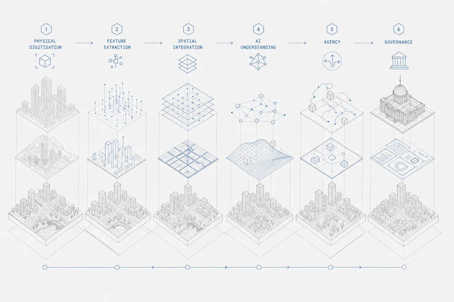
From making the world machine-readable to letting machines participate in it
There is a surprisingly straight line between the two eras.
The first era of urban technology was about translating reality into a language computers could understand. A tree became a coordinate, a road became a geometry, a building became a polygon, a manhole became an object in a database.
What is happening now is the reverse direction becoming possible.
The machine can increasingly translate its understanding of the world back into actions that alter that world:
- A detected pothole becomes a work order.
- A changed building becomes an inspection.
- A leaking pipe becomes a maintenance dispatch.
- An anomalous pollution plume becomes an investigation.
- A flooded street becomes a response workflow.
So perhaps the progression is even simpler than “maps to agents”:
The first phase made the physical world machine-readable.
The second made that world machine-understandable.
The agentic phase makes the machine capable of participating in it.
And once that happens, the hardest questions move once again from computation to authority, accountability and design:
- What should the machine be allowed to decide?
- At what confidence threshold?
- On whose authority?
- Which actions require human judgment?
- Who owns the audit trail?
- Who is accountable when the system is wrong?
- And ultimately, what outcome was the intelligence supposed to produce?
The story of smart cities was never really about smarter maps. It was about progressively closing the distance between reality, knowledge and action.
In the first phase of smart cities, the missing layer was reality. In the years that followed, AI attacked knowledge. Agentic AI is now attacking the distance between knowledge and execution.
And when that distance becomes small enough, the digital twin stops being something we look at. It becomes part of how the city acts.
Footnotes
-
"Once trained, they can be adapted to many GIS workflows – from similarity search and predictive modeling to feature extraction and natural language interaction with imagery – with far less training data and effort." — Esri, Introducing Geospatial Foundation Models in ArcGIS (2026-07-12). ↩